NYC’s High Line is the greatest outdoor space created in Manhattan since Central Park. The city converted 1.45 miles of what was once the NYC railroad into an elevated outdoor space perfect for exercising, strolling, and taking in the skyline from the Meatpacking district to the Javits center on Manhattan’s west side. If you’ve been lucky enough to visit you know it is a spectacular addition to New York City. And now, right here in Bucks County, we’re getting our very own version as unused rail lines are being transformed into multi- use pedestrian trails.
Bucks County Rails and Trails
Bucks County is rich with outdoor areas perfect for biking and hiking including the 60-mile long D&L Canal Path. With the conversion of unused rail lines, residents will be able to enjoy even more options for recreational activities and alternatives to getting in their cars to get into town. In Upper Bucks, the Highlands Trail an already successful part of this rails and trails conversion begins in Coopersburg and follows the entire length of the Upper Bucks Rail Trail. The trail follows the unused rail corridor south toward Quakertown for a distance of three miles, connecting to Veterans Park on East Pumping Station Road in Richland Township.
With the rails and trails project, many other areas including Southampton, and Newtown, both on the 8.7-mile trail- formerly the Fox Chase line, running from Newtown into Pennypack park are anxiously awaiting the joys of this program’s expansion. The first segment, which is now open, extends 2.5 miles from County Line Road to Bristol Road in Upper Southampton Township and runs through the heart of the Southampton community.
Full Steam Ahead
Before:
After:
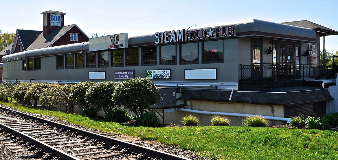
Southampton’s Steam Pub, owner, Martin Hoeger, wholeheartedly shares the vision of Bucks County’s Planning Commission. His restaurant Steam Pub is positioned on the unused Southampton rail line that once connected this portion of Bucks County to Philadelphia, and thus the rest of the county. Steam Pub has been a place for locals to unwind with delicious food and drinks in a fun and vibrant atmosphere, and with the conversion of the rail line now locals can walk or bike to the restaurant.
A trailblazer himself, Martin already has plans for converting the historical Southampton train station across the tracks from Steam Pub into a coffee, ice cream, and smoothie shop called the Steam Coffee Company. As the rendering below shows, all things train station and rail line will be celebrated here from the quaint, fully renovated station to the server’s uniforms. Martin, a lifelong Southampton resident, says expanding the rails and trails project will give life to the center of town and it’s just the start to what the future of the pike could be.

Next Up the Newtown Rail Trail
Steam Pub sits on the first 2 miles of the portion called the Newtown Rail Trail in Upper Southampton from County Line Road to Bristol Road. This portion is open with an official opening planned for this spring.
Churchville and Newtown – you’re next! Once completely constructed, the Newtown Rail Trail will extend a total of 8.7 miles from County Line Road (border of Bucks and Montgomery Counties and end of the Pennypack Trail) to Newtown Borough.
The next segment, which the County is in the process of designing, will be a total of 1.7 miles. The first 1.4 miles will extend the rail trail north along the old rail line through the northern part of Churchville Village and over Churchville Reservoir until it turns in to the County-owned Churchville Nature Center. Here, a 0.3-mile connector segment will link the Nature Center’s Parking Lot to the trail and serve as a trailhead. The design is estimated to be finished by Spring 2024 and the construction of this segment is estimated to be completed by Summer/Fall 2026.
The remaining portion of the trail within Northampton Township will extend 3.2 miles to the Neshaminy Creek. The total trail mileage within Northampton Township would be 4.8 miles. After crossing the Neshaminy Creek, the trail will extend 1.3 miles to reach Newtown Borough, running 0.5 miles through Middletown Township, 0.4 miles through the lower part of Newtown Township, and 0.5 miles into Newtown Borough where the trail concludes.
Win, Win, Win
“It’s all about connections,” says Rich Bahler of Bucks County Planning Commission. Connecting portions of Bucks County with neighboring areas creates community and brings vitality to the areas. In addition, each portion of the trail will have unique features including fencing for homeowners on the trail, lending libraries, and mile markers for both tracking your progress and safety in case of emergency on the trails.
The Rail Trail project will bring life to communities. Not only will the trail strengthen ties between Bucks County’s communities it will provide a direct link with educational facilities within the Churchville Nature Center.
Get on the Trail
The big apple’s High Line park has nothing on Bucks County. See for yourself. Click here for more info on trailhead access sites, parking and to plan your next walk or ride on Bucks County’s rails and trails.

We Are Supported By:


